Showing posts with label Turkey. Show all posts

Sunday, April 23, 2023

Perge


Perge is one of the most important ancient city of the world was situated is 18 km east of Antalya Province.

The Hittites had settlements in this area around 1500 B.C., and St. Paul stopped here on one of his journey during the time when Perge was an important city of ancient Pamphylia.


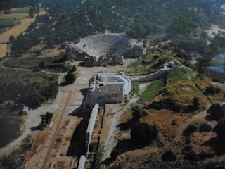
Perge

The stage of the theatre has very nice marble relief work. On the outer wall is a three sectioned memorial fountain. Some of the reliefs from the city are displayed in the stadium for easy viewing. Other ruins worth mentioning are the handsome city gate flanked by two lofty towers, a long colonnaded street that was once lined with shops and mosaic pavements, a large agora, and buildings that used to house the baths and gymnasium.

Side


Side, which is 7 km from Manavgat and 70 km from Antalya, is an ancient living center whose name meant pomegranate in Anatolian language. Side, which is aforecited by historians as being founded in 1405 A.D., had been ruled by the Lydians, Persians, Alexander The Great, Antiogonous and Ptolemaioses in turn, beginning from the second half of Vith century A.D. After 215 A.D., the city, which had amended thoroughly under observation of Syrian Kingdom, turned into a scholarly and cultural center in this duration. Having been left to the Bergama Kingdom as a consequence of the Apameian agreement, the city later protected its freedom along with the Eastern Pamphilya region. The city soon flourished, gaining tremendous wealth and riches with a huge commercial navy.

It entered Byzantium rule after Roman rule after 78 B.C. Side, which was a Pontiff center during V’th and VI’th centuries, had lived its biggest times during these years.


Side

The main gate of the city, which has a unique exertion, lies between two towers. There are two main streets in the Side province. These streets are typical examples of the columned streets from the Ancient Age. After passing city gate, the flat stones adorned area is the starting point of this street. There are columned porticos beside both sides of these streets, and shops behind them.

There is a “Nymphaeum”, the largest historical fountain of Anatolia, which is found against city gate, outside the bulwarks. A wide pool place is below this foundation. You can reach a monumental structure by passing through a street after the theater. This building with dimensions of 100x100m, is an agora, in which lies the Bazaar area of the city. This area is surrounded by porticos and there are shops on three sides of it. There is a Gymnasium, surrounded by porticos and composed of three halls, on the street to the south side of the Agora. in the main street on the north to south direction, there is an arched structure, which was constructed during Roman Period. importance of Side city’s theater, in connection with architecture, is its construction on arched places instead of the slope of a hill like other roman theaters.

The theater, which is composed of three divisions: the cavea, orchestra and scene, is the biggest and most monumental one among the Pamphylia theaters, and has a capacity of 20.000 spectators.


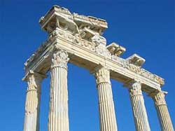
Temple of Apollo, Side

There are wide cemeteries outside of Side’s bulwarks, with the most important one of these being the western necropolis, which is 1.5 km away. There are also temples and aqueducts in Side. The most important temples in the region are the Athena, Apollon and Men temples. The water of Side is brought from the Dumanli source, within Oymapinar Dam Lake, almost 25 km away. This water transportation system is composed of ten aqueducts, of which some are two layered. The biggest one is near to Oymapinar and has 40 specs.


Patara


Altough it is not useable now, with its natural harbor also a fiord this city has become a doorway to World for Ancient Lycia. As the famous Roman Historian Livius wrote: “caput gentis Lycia” with this title Patara was the capital of Lycia Union at B.C. 167/168. In the light of current information we have today, Patara is known to be first settled around B.C. 3000 and it was the last city that Hittite King Tuthaliya (B.C. 1300)  visited on his Lukka expedition. Patara has also been the capital of both Lycia Province built in Emperor Claudius period (A.D 43) and Lycia Pamphylia Province  built by Emperor Vespasian (A.D 73/74). With its harbor this city held a big role on political and economic history of whole area, also being the center of “Apollon from Lycia” prophecy and by the fact that Santa Clause  “St. Nikolaos” was born and lived in here is supporting Patara’s importance on religious history too.

The arch that symbolising city’s monumental entry with with its height of 10 meters  is emphesising Patara’s glory. It is known by the writing on it as “From Metropolis of Lycia Pamphylia Province Mettius Modestus” this is an Arch of Honor built around A.D. 100. Entered by this monumental door, this city is one of the most glorious ancient cities of Anatolia with its still standing five bathhouses, thirteen churches, storehouse by harbor (horreum), many temple graves, stadium and many other buildings.

As one of the most important ports of the ancient Lycia, Patara is a heavenly place that enjoys nature’s generosity. Patara, with its silt sand, which reminds one of a desert, its clean and clear waters, ancient city, and world-renownd beach, hosts thousands of tourists every year. Gelemis village and the ancient city of Patara lie hand in hand. The ancient city, Iocated right behind the tong beach, which extends for 18 km, includes an amphiteater, aqueducts, mausoleums, tombs, and a church, which were discovered after many archaeotogical excavations.
The newly restored amphitheater dates to 2 B.C. and has a capacity to hold approximately ten thousand spectators. A littte farther in the distance, you can see the ruins of the lighthouse, which is thought to be the first Iigthouse of the world. However, a great part of the city is buried under the sand carried from one place to another by the strong winds. Acacia trees and other plants that were planted as part of a project that aimed to prevent the free transportation of sand add a special beauty to the region, white deep pink colored oleander ftowers and pine trees cornplemcnt Patara’s natural beauty. The road to Patara Beach passes through the ancient city. Patara, a city with its back on a high mountain that separates a wide valley from the sea, was the place where the Ancient Greeks lit their first fire after coming to Asia Minor. Believed to have been foundod by Pataros, son of the Greek God Apollo and the nymph Lykia, Patara was also the birth place of the Apotto sect.


Patara

According to Lycian rnythology, Leto gave birth to her twins Apollo and Arternis on this land and gave them their first bath in the Xanthos (called as Esen today) Creek. For this reason, the creck is considered holy according to Christian belief. Moreover, St. Nicholas, one of the greatest Christian saints who is also known as Santa Claus, was born in the third century B.C. in Patara according to Byzantine records. Only two km coast line of Patara is used as a beach. Therefore, there is only a single kiosk that sells refreshments and food. Since alI sides of the beach are open to the sea, huge waves always pound the shore in Patara. With a length of 18 km, Patara is the longest heach of Turkey with its narrowest part 280 m and widest part almost 1,500 m. It is also listed by the Ministry of Environment as a National Park and protected region. Patara’s secluded beach area is also a breeding ground of Loggerhead Marine Turtles Caretta caretta. Persons who go through a sand cure in this beach, which has a type ot microorganism which used to be an indicator of a clean sea thousands of years ago, are freed lrom physical pain and aches.

Patara is the activity center of Kas and Kalkan. Visitors come here to enjoy water sports, canoe trips, hikes in the nature, and horseback and motor safari tours in the sand dunes. We participated first in a horseback safari and then a canoe trip. in the history of early Christianity, Patara was an important episcopal center, and a busy port during the Roman period, where as today, Patara port is covered with sand dunes. The sand brought by the winds began to fill the port, which is 400 m wide and 1,600 m deep, and soon, the city became almost invisible. Indeed, the wind here blows the sand so fiercely that it is extremely difficult to keep your eyes open. One can tour the sand dunes the coastal line and the ancient city on Hafringer breed horses, provided by the tour operator. Canoe trips cover crossing the Esen Creek, which starts from the Saklikent Canyon with one branch passing through Kinik. The canoes resembles those used by American lndians.

Esen Creek starts running under the bridge in Kinik and travels for 16 km before reaching Cayagzi (River Mouth), and it takes almost four hours to travel by canoe. lf you go to Kinik for a canoe trip, you should also visit the ancient city of Xanthos. The most striking historical edifice in this ancient city that had maintained its independence until the Persian sovereigny is the monument of war. This 8.87 meteý high monument consists of a massive pedestal carved in rocks and a small tomb chamber with four sides decorated with friezes. The reliefs in this chamber covered with a lid were plundered and taken to London in 1842 by British adventurer Sir Charles Fellows and the original pieces were replaced by copies made of plaster. The nearby Harpies Tomb gets its name from the mythological harpies half birds, half women creatures carrying away dead children to the underworld.


Olympos

 The second seaport city of Antalya is Olympos. This ancient city is situated on the southern of Mount Tahtali. Whether coming by sea or land do not miss the Olympos Valley shaded with oleander and laurel shrubs and the refreshing quiet pools of flowing water. The design of the mosaics in the Olympos bath is enhanced by the play of light while a temple gate and a theatre are of interest along with the other walls and towers around the bay which date from the Middle ages.


Olympos

North of Olympos, up from Cirali Beach, is Yanartas (at a height of 300 mt) where, according to mythology the fire breathing monster, Chimaera, was slain by the Lycian hero Bellerophon who was mounted on his winged horse, Pegasus. Nearby you can see remains from the Byzantines who attached religious importance to the area. Tranquil waters and sandy beaches line the Bay of avus, situated south of Olympos. This enchanting bay is yours for an unforgettable experience of water skiing on glassy water, for discovering the colorful marine life in waters clear enough to see the bottom, or exploring the incredible sea caves on the northern shore.

Olympos is a excellent place for scuba and rock climbing.

Manavgat


Between the Taurus Mountains to the north, and the sandy beaches of the Mediterranean coast, much of the district is surrounded by a flat plain. This is mostly fertile farmland and agriculture is well-developed in Manavgat, keeping livestock and growing crops including grains, sesame and many fruits and vegetables; in recent years olives have also been planted. There is no industry except for food-processing, so apart from agriculture the local economy depends on tourism.

The mountains are covered with forests and typical Mediterranean shrubs, there are small plains higher in the mountains too, traditionally used for summer grazing by the yörük nomads. Manavgat has a Mediterranean climate of hot, dry summers and warm, wet winters; the temperature rarely drops to freezing. The district is irrigated by the Manavgat River, and has two dams for hydro-electric power. In 2001 plans began to export water from these reservoirs to Israel and other Mediterranean countries including Malta and Cyprus; as of 2006 these plans are on hold.

The ancient cities of Side and Selge date back to the 6th century BC. Manavgat was taken over by the Seljuk Turks in 1220 and the Ottoman Empire in 1472.


Manavgat Waterfall

With 64 kilometres (40 mil) of hot, sunny coastline, much of it sandy beaches, with a long river and the waterfall, well-protected countryside including mountains and forests, Manavgat has an important tourist industry. There is plenty of accommodation on the coastline and many places to explore including historical sites, rivers, streams and caves. And there is the sea itself including the odd experience of swimming from fresh water into the salt sea at the rivermouth. Predictably the cuisine includes fish from the Mediterranean.

The huge influx of visitors every year is changing the shape of traditionally conservative Manavgat considerably; there are bars, discos, and all kinds of youth culture which 20 years ago would have been unthinkable. The villages of Kumköy and Ilýca on the coast are particularly lively.

The town of Manavgat has grown rapidly and chaotically, mainly with cheap apartment buildings, and the roads and other services are struggling to keep up. While keen to exploit the opportunity to the last cent, the people here are resisting the effect of foreign visitors on their traditional lifestyle as much as they can.


Kaş

 In Kas (it means Eye Brow in Turkish) the traces of the Lycian civilizition are visible even today, desbite numerous modern buildings have been built here. Small houses with exquisite windows and Bouganvilles cluster only the town’s narrow streets, but all the same, Kas remains as one of the most untouched Mediterranean ports. A small amphitheater to the west of Kas, which is located right acroos the Greek Island of meis (Kastellorizon) and the Lycian tomb in uzun carsi are the most important symbols of the Kas’s passionate embrace of its historic past. In addition to the the archaeological riches in the surrounding area, Kas itself is an ancient place of value. Habesos, a name given to its many hotels, is the oldest name of this ancient city. Hoeover, the city was also called Antiphellos. Situated at the crossroads connecting the ancient regions of Caria and Lycia, Antiphellos, was also a trading port. During the Anatolian campaign of Alexander the great, Kas came under his rule, but after Alexander the great died, the regionwas ruled by the Seleucids and later by Ptolemies dynasties.

The most notewortly historic sites in the ancient city, which played a significant role in the Roman period and became the episcopal center in the Byzantine Era, are the tombs carved in the rocks in the north of the city and the Lycian mausoleum is the 4th cebtury Lycian Mausoleum, which is known as the King’s Mausoleum among the public and is in the Uzuncarsi Street today. The ancient amphetheater of Kas is one of the most important historic works of art in ancient Antiphellos. Dating from 1st century B.C. the theater has a seating capacity of 4000, and it is the only theater in Anatolia that faces the sea. Having the most divergent geography in the Mediterranean region, Kas was built in a bay on a peninsula that extends to the sea in curves, on rocks and on the slopes of steep mountains. Thus, all boardinghouses in Kas can be reached only through climbing high stairs. there are no beaches in the center of Kas as it is built on rocks, but you can use the Kucuk and Buyuk Cakil (Small and big Pebble) beaches in the western quarter of the peninsula. Kucuk Cakil is near the town center and is arranged in the form of a sea park, whereas Buyuk Cakil is a public beach located in a calm and modest cove. Another beach is Limanagzi, which you can reach by boats that set out to sea from the port. Howover, Kaputas beach is the most popular beach in Kas and Kalkan. You must descent 192 steps in order to reach the beach that is inside a deep curve of rocks located 19 km from Kas, but it is worth seeingbecause this place is a heaven on earth with its turquoise blue waters and golden sand.


Kaş Houses

Moreover, you can also go on a boat cruise if you are Iooking for an alternative way of spending your time. The Kekova Tour that includes rests in Yaglica , Inonu Cove and the Aquarium Cove is just the right thing to do. You can visit Kekova, which has the richest shipwrecks and sunken cities in Turkey and go scuba diving by participating in tours during which you will follow the coast line and than stop by Simena, Uc Agiz and the Sunken City. The most attractive sea cave in Kas and the surrounding area is the Sea Cave of Asirli island. The port, marketplace, buildings, restaurants, boutiques, cafes, and shops in Kas have a bohemian touch… Perhaps that’s why visitors Kas as well as its residents who have left big cities and hood refuge here are usuaily intelectuals. In Kas, listening to street musicians while strolling thrugh Uzun Carsi. Kas offers opportunitues for all types of water sports as well as paragliding, hikes in nature, and boat cruises. Plateau tourism is also a rising trend. he ruins of the ancient city of Antiphellos can be seen in the Felen Plateau, located at 12 km to Kas.

Kalkan


Kalkan., the rising star of Turkish Turquoise Coast where the renowned Greek poet Sappho had once lived, is 27 km from Kas and 215 km from Antalya. Popular mainly among tourists who enjoy a bohemian life, as well as British guests, Kalkan was formerly an old Greek village. Although it is sad to observe that the white washed houses decorated with Bougainvilles and spectacular gardens gradually become fewer and that the slopes are covered with newly built summer houses with every passing day, Kalkan still has the power to make you feel as if you have come across a good old friend. A much younger settlement area than Patara, Xanthos or Letoon, Kalkan used to be a secluded and calm fishermen’s village until 1960 and was quite dificult to reach by land due to the lack of roads. Villagers used to come to the port only on horses, donkeys or camels. Caravans loaded with charcoal, grains, silk, olive oil, cotton, wine, pine acorns, and cedar wood sold their goods to ships heading for Alexandria, Haifa, Rhodos, Smyrna. and Constantinople, and in return, received dry goods and notions, rice, sugar, and salt. In the l9th century, Kalkan was the most important port in the Teke Peninsula, and its people led a modern life in prosperity. However, when the time for the exchange of Turkish and Greek populations arrived, the Greek populace, who constituted 80 percent of the population. migrated to Greece. Most of these migrants established the city of Kalamaki near Athens, while some went to Australia, where they founded the Kalamaki Clup.


Kalkan

Kalkan is an urban protected area. The houses lining along the streets in the form of terraces that descend from above. The terraces from which one can view the sea, are arranged perfectly in accordance with the Mediterranean climate so that they can make the most of the breeze. Their small and narrow balconies, wide and spacious terraces, wooden doors, windows with shutters, and whide washed exteriors reflect the architectural traces of the Greek Island of Meis, but their most decorative elements are the handworked bearing bars between the floors and the grills above their windows. The false columns and column heads ornameting the corners of buildings, the handwork on the roof edges, and the wooden doors turn these houses into picture postcard settings.

Some of the houses were restored by following the original plan, while others were built from scratch by taking the traditional stracture as a model. Traditional Turkish houses, though very few in number, can also be seen. These building are set along Greek houses. Eski Ev Boarding House and the adjacent wooden house with a brown balcony are the most remarkable examples of these Turkish houses. The old customs office buliding is the most pompous structure in Kalkan. It was built by a Greek notable in 1854, and at that time, the ground floor was used as a local pub, and the upper floor was a boarding house.
For swimming, you can use the Kalkan shore only at designated spots because in addition to fisherman’s boats and motorboats, blue voyage schooners and yachts also anchor here. On the left end (when you arefacing the sea), you wiII see a public beach covered with pebblestones. The beach on a rock platform to the right of the port is managed by a few establishments, and can be used in return for a fee.
Beaches on rock platforms are also present on the opposite cove in Kalkan, and you should definitely visit thern! The famous Club Patara Houses (timeshare villas and a hotel) ara the good places for staying in Kalkan. The adjacent hotel called MahaI de Kalkan hosts select guests.

In Kalkan, the sea is always crystalline blue, but it does not get warm enaugh for swimming until the end of June. Especially in the uninhabited and calrn coves that are popular among people who go on daily boat cruises… Kalkan offers a wonderful alternative ta a sea-and–son holiday: plateau tourism. Situated at half an hour ta Kalkan, Bezirgan Plateau is a colorful village known for its salmon trout farms and horseback safari tours. A good way to spend the evening in Kalkan is going to a terrace restaurant. AlI restaurants have terraces that offer a fabulous view of the sea. Atter dinner, you can go to Yacht Point, where persons have a good time until the late hours of the night, visit Koko or go to the seaside ta watch the stars.
As we have said before: Kalkan is a place where the stars ara closer… Herodotus, the “father of history” had this to say about Kalkan: “The Stars look the closest in Kalkan,” and this observation entered his ancient hook of history. Kalkan beach has blue flag.

Finike


Finike (ancient name is Phoenicus) is a district on the Mediterranean coast of Antalya Province of Turkey, 90 minutes west of the city of Antalya.

Finike is located in the south of the Teke peninsula, and the coast here is a popular tourist destination. However, Finike is best-known for its oranges, the symbol of the town.

For centuries Finike, then named Phoenicus was a trading port, the main port of Limyra, the capital city of Lycia. Phoenicus was said to have been founded by Phoenicians in the 5th Century BC, and thus named after its founders.


Finike

 The area has been inhabited for much longer than that, archaeologists have found evidence near the town of Elmalı showing that the Teke peninsula has been settled since 3000 BC (although on the coast nothing has been uncovered dating before 2000 BC).

Trade along the coast was established first by the Persians, who relinquished Lycia to the armies of Alexander the Great. However the coast was always vulnerable to forces from Syria, Egypt and Rhodes until it was brought within the empire of the Ancient Romans and the succeeding Byzantines.

Even then the Byzantines were threatened by the Arab armies of Islam. Eventually the area was lost to the Seljuk Turks in the 13th century. These were succeeded by the Ottoman Empire from 1426 AD.

The local economy depends on agriculture, particularly oranges and other citrus fruits. This is supplemented by income from tourism in the summertime, although because of the lucrative orange production and the distance from Antalya Finike has not seen the large-scale tourism boom that has so radically changed the other coastal districts of Antalya. Finike is a quiet district where people buzz around on mopeds going about their daily lives. Indeed many of the visitors that Finike does attract are retired people in search of relaxation. A type of pale limestone is quarried at Limyra, and sold as a decorative building material.

The port of Finike is now a yacht marina, and has a small fishing fleet. The coast is rich in marine life including sea turtles and fish including local specialities red porgy Sparidae and grouper (Epinephelus); other fish found along the coast include leerfish Carangidae) and the more widespread Mediterranean varieties such as bluefish, sea bream, sea bass, with swordfish, sardines and others found further out to sea. However the coast suffers from overfishing and many varieties, including the porgy, are in decline.

The beaches of Finike are an important nesting ground for the caretta caretta sea turtles, and the rocky parts of the coast are used by the rare Mediterranean Monk Seal.

Elmalı


Elmali is a town and district in Antalya Province, the Mediterranean region of Turkey. It lies about 35 km (22 mi) inland, near the town of Korkuteli and 110 km (68 mi) west of the city of Antalya. In 2007, the population for the whole district was 36.213, of which 14,038 live in the town of Elmali. Formerly known as Kabali and Emelas.

Elmali is a small plateau at the head of a long upland valley in the Beydaglari range of the western Taurus Mountains, surrounded by high peaks including the 2500m Elmali Mountain. Aside from the town of Elmali, the district includes two other small towns (Akcay and Yuva) as well as villages. The area is watered by streams running off the mountains. Although close to the Mediterranean, Elmali is high in the mountains and has an inland climate of cold winters and hot summers, (although still much cooler than the coast). Near to Lake Avlan there is an area of cedar forest, rare in Turkey.

Excavations, by Machteld Mellink from Bryn Mawr College, of the burial mounds of Semahöyük and Müren have shown signs of copper production dating back to 2500 BC. The area was later a key town in the north of the antique province of Lycia, and the Lycian Way trade route came through here. It was a small town of Asia Minor in the province of Konya in the Ottoman era, then the administrative centre of the ancient Lycia, but not itself corresponding to any known ancient city. According to Britannica, the town was inhabited by direct descendants of the ancient Lycians, who had preserved a distinctive facial type, noticeable at once in the town population. There were about fifty Greek families, the rest of the population (4000) being Moslem (as of 1911). The plain was subsequently controlled by the Ancient Romans, Byzantines, and the Seljuk Turks. The town was the headquarters of Beylik of Teke clan of Anatolian Turkish Beyliks when it was brought into the Ottoman Empire at the time of Sultan Bayezid I. It remained a key mountain stronghold in the Ottoman period and through the early years of the Turkish republic, but has declined as recent generations have left the dry mountainside for jobs on the coast or in Turkey’s major cities.

The district’s economy is largely agricultural; 37% of the land is planted. In keeping with its name, (literally apple-town) Elmali produces 12% of the Turkey’s apples. Other fruit and vegetables are grown here too, the local leblebi (dried chick peas) is delicious.

Few tourists come to Elmali although the town is beginning to attract visitors thanks to its rich traditional architecture and beautiful mountain surroundings; these people are either day-trippers or passing through en route to the Mediterranean coast, but do bring important income to the area. Also some residents of the coastal towns such as Finike, Fethiye or Kas have holiday homes in Elmali, a retreat from the summer heat on the coast. There is little industry or manufacturing in the district, only a brickworks, flour and feed mills, and a fruit juice plant.

Most people live in cottages and wooden houses, but there are some apartment buildings in Elmali itself, a small town of 14,500 people with banks and other essential services. The infrastructure in the villages is basically little more than telephones, and elementary schools. Each village used to have a traditional guest house (köy evi) but many are in disrepair today.

The cuisine is typical of Anatolia, you will find ladies grilling the flat bread gözleme by the roadside, but Elmali is known for its various ways of using sesame, including baked beans served with a lemon and sesame relish (Antalya usulu piyaz). Another local speciality is a goats milk ice-cream. And of course one of the most delicious things in Elmali is the cool mountain spring water. Or a glass of tea made with it.

Demre

 Demre is on the coast of the Teke peninsula, west of the bay of Antalya, with the Taurus Mountains behind. The mountains are forested and the coastal strip is made of good soil brought down by the mountain rivers. The climate is the typical Mediterranean pattern of hot dry summers and warm wet winters.

 Before the tourism boom began in the 1980s the local economy depended on agriculture, which is still important today. The villages of Demre grow pomegranates and citrus fruits and now a large quantity of fruits and vegetables all year round in glass houses. Also with its rich history, attractions like the island of Kekova, the sea and warm weather this coast is very popular with holidaymakers from Turkey and all over Europe, although Demre still does not have the high volume of tourists enjoyed by districts nearer Antalya airport. Some local handicrafts like rug making, and events such as the annual camel-wrestling festival bring in extra income.

Demre

 The local cuisine predictably includes fish and seafood from the Mediterranean.

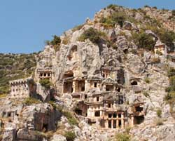
Myra was one of the most important cities in antique Lycia. Coins have been found dating back to 300 BC but logically the city must have been founded centuries earlier. The city thrived as part of the Roman Empire and many public buildings were constructed.

The earliest church of St. Nicholas at Myra was built in the 6th century. The present-day church was constructed mainly from the 8th century onward a monastery was added in the second half of the 11th century.

In 1863, Tsar Alexander II of Russia purchased the building and began restoration, but the work was never finished. In 1963 the eastern and southern sides of the church were excavated. In 1968 the former confessio (tomb) of St. Nicholas was roofed over.

Alanya

Alanya is a seaside resort city and district of Antalya Province in the Mediterranean Region of Turkey, 120 km from the city of Antalya. The municipal district, which includes the city center, has close to 400,000 inhabitants. The population is almost entirely of Anatolian origin, but is home to around 10,000 European residents, with a growing presence in the city and its economy.

 Because of its natural strategic position on a small peninsula into the Mediterranean Sea below the Taurus Mountains, Alanya has been a local stronghold for many Mediterranean-based empires, including the Ptolemaic, Roman, Byzantine, and Ottoman Empires. Alanya’s greatest political importance came in the Middle Ages with the Seljuk Sultanate of Rûm under the rule of Alaeddin Keykubad I, from whom the city derives its name. His building campaign resulted in many of the city’s landmarks, such as the Kizil Kule (Red Tower), Tersane (Shipyard), and Alanya Castle.

Alanya

 The relatively moderate Mediterranean climate, natural attractions, and historic heritage makes Alanya a popular destination for tourism, and responsible for nine percent of Turkey’s tourism sector and thirty percent of foreign purchases of real estate in Turkey. Tourism has risen since 1958 to become the dominant industry in the city, resulting in a corresponding increase in city population. Warm-weather sporting events and cultural festivals take place annually in Alanya.

The city has changed hands many times over the centuries, and its name has reflected this. Alanya was known in Latin as Coracesium or in Greek as Korakesion from the Luwian Korakassa meaning “point/protruding city” Under the Byzantine Empire it become known as Kalonoros or Kalon Oros, meaning “beautiful” or “fine mountain” in Greek The Seljuks renamed the city Alaiye, a derivative of the Sultan Alaeddin Keykubad I’s name. In the 13th and 14th centuries, Italian traders called the city Candelore or Cardelloro In his 1935 visit, Mustafa Kemal Atatürk finalized the name in the new alphabet as Alanya, changing the ‘i’ and ‘e’ in Alaiye, reportedly because of a misspelled telegram in 1933.

Kleopatra Beach Alanya

Since the first modern motel was built in 1958, considered the first year of the tourism industry in Alanya, hotels have raced to accommodate the influx of tourists, and the city as of 2007 claims 157,000 hotel beds. Damlatas Cave, which originally sparked the arrival of outsiders because of the cave’s microclimate, with an average temperature of 22 °C and 95% humidity, is accessible on the west side of the peninsula with trails from Damlatas Beach. Many tourists, especially Scandinavians, Germans, Russians, and Dutch, regularly vacation in Alanya during the summer months. They are drawn to the area because of property prices, warm weather, sandy beaches, access to Antalya’s historic sites, and fine cuisine. Other outdoor tourist activities include wind surfing, parasailing, banana boating and Turkey’s largest go-kart track. Hunting season also attracts some tourist for wild goat, pig and partridge hunting in area nature reserves.

Welcome to Antalya Turkey

Antalya is placed on a terrace made by the traventines which is ending with the high perpendicular cliffs 25-30 mt far from the sea shore ...